A late‑season winter storm is actively impacting the Western United States, with significant snow, plummeting temperatures, and hazardous travel conditions documented across Colorado, Wyoming, and Utah. Forecasters and emergency officials are urging caution as multiple weather advisories remain in effect.
Winter Storm Colorado Wyoming Utah: Storm Overview
- A powerful cold storm system moving from the Pacific Northwest into the Rockies is producing snow accumulations and hard freezes well into mid‑April, an unusual but not unprecedented event this time of year.
- Snowfall totals across the Colorado foothills reached 6 inches, with areas like Denver logging measurable snow after a long dry spell.
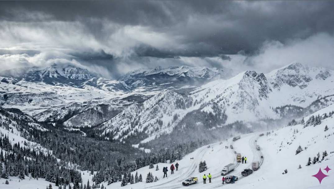
- Mountain highways spanning Colorado, Wyoming, and Utah are under Winter Storm Warnings with the potential for 12–24 inches of snow, especially at higher elevations.
Regional Impacts
Colorado
- The late winter blast brought snow to parts of the foothills and mountain passes, leading to icy travel conditions and hard freezes along the Front Range.
- Interstate corridors like I‑70 over mountain passes saw snow and black ice warnings, prompting advisories for drivers to exercise extreme caution.
Wyoming
- Snowfall and cold air have pushed into Wyoming’s river valleys and high plains, with impacts extending along I‑80 and other major freight routes. Mountain passes remain treacherous for motorists.
Utah
- The storm brought snow and freeze warnings statewide, including valley snow in parts of northern Utah, contributing to slippery roads and localized travel hazards.
Why This Storm Matters
Unusual Late‑Season Cold
Meteorologists emphasize that while late‑season snowstorms are not unheard of in the Rockies, the timing and breadth of this system — spanning three major states — is notable. The storm is accompanied by temperatures far below seasonal norms, increasing the risk of black ice, road closures, and travel disruptions.
Snowpack & Drought Context
Despite the recent storms, states in the Intermountain West remain in snow drought conditions:
- Colorado’s snow water equivalent (SWE) levels are well below seasonal averages, even with recurring snow events.
- Utah similarly has record‑low snowpack in many basins, which has implications for water resources, river flows, and wildfire risk later in the year.
These conditions highlight that isolated snowstorms do not offset long‑term moisture deficits across the region.
Safety & Preparedness Tips
If you’re in or traveling through the affected region:
- Delay travel if possible when storm warnings are active. Heavy snow and sudden black ice create dangerous highway conditions.
- Equip vehicles for winter — winter tires, adequate tread depth, and emergency supplies can be lifesaving.
- Monitor local NWS advisories closely, as warnings and road conditions can change rapidly.
Expert Takeaway
This evolving winter storm underscores the volatile nature of late‑season weather in mountainous regions. While winter’s grip loosens across most of the U.S. by April, the Rocky Mountains — including Colorado, Wyoming, and Utah — remain vulnerable to cold air intrusions and late snowfall events. Whether for travel planning, community safety, or water‑resource forecasting, staying informed through reliable sources is critical during dynamic weather patterns.